Track City of Miami trolleys live
Track City of Miami trolley arrival times in one app. Get live ETAs, route details, stop lookups, maps, and favorites for iPhone and Android.
Everything you need for the City of Miami trolley system
Check live ETAs, route details, stop information, and maps for the City of Miami trolley routes whether you ride every day or just need a quick connection.
Live Arrival Times
See when your trolley is actually arriving, not just the printed schedule. Live ETAs update throughout the day when live data is available.
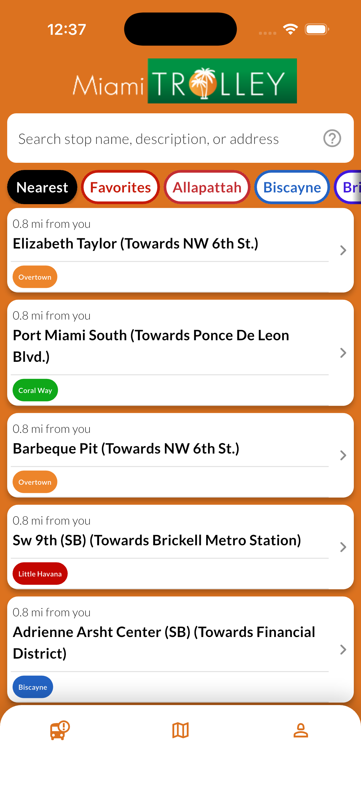
Search by Stop Name and Route
Find the stop you need faster by searching with the stop name and route you already know from street signs or rider guides.
Routes, Stops & Maps
Browse each route, open stop details, and jump into the map to understand exactly where to board.
Favorites for Daily Trips
Save your regular stops so you can get back to the arrivals you care about without starting over each time.
Free to Ride. Free to Use.
No sign-up, no account, and no fees. The City of Miami trolley service is free to ride, and the app is free to use.
Available in Spanish
Use the app in English or Spanish whether you live in Miami or you are visiting downtown, Brickell, or nearby neighborhoods.
See how the app works
From nearby stops and live arrival times to route maps and favorites, here is what Miami City Trolley Tracker looks like in use.
Nearby Stops
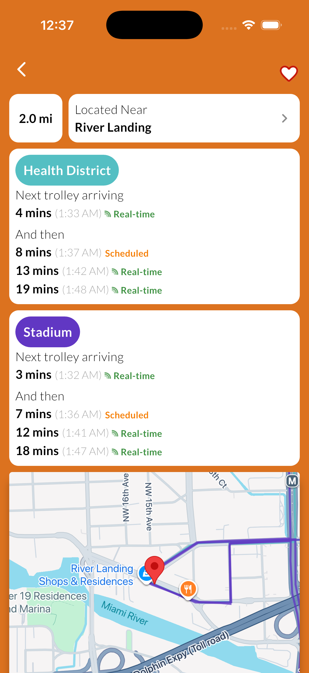
Live arrival times that make connections easier
See when the next City of Miami trolley is expected at your stop. Each arrival shows whether the time is a live GPS-based ETA or a scheduled estimate so you can decide when to leave.
Live ETAs
GPS-based arrival times when live data is available
Multiple routes per stop
See every trolley route serving your stop in one place
Embedded map
Open the map to see exactly where your stop is located
Navigate in Maps
Open any stop directly in Apple Maps or Google Maps.
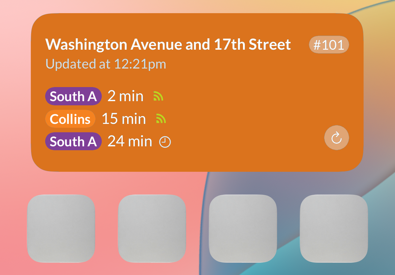
Home Screen widgets are coming soon
Miami City Trolley Tracker will support Home Screen widgets in a future update. For now, use the app for fast stop lookup, live arrivals, maps, and favorites.
Quick stop access
Pin your favorite stop details to the Home Screen as soon as widget support launches.
Live arrivals at a glance
The widget experience is planned to surface the next trolley without opening the app first.
Disponible en español
Si prefieres usar Miami City Trolley Tracker en español, abre la versión en español del sitio.
Made for everyday riders and quick city connections
Whether you commute, run errands, or need to get across the city without guessing, the app helps you spend less time waiting and more time moving.
New to the City of Miami routes?
The City of Miami trolley network can be easy to use once you know which route serves your area. The app helps you compare routes, stops, and arrivals before you head out.
- Find the closest stop near Downtown, Brickell, or nearby neighborhoods
- See which route gets you closer to your destination
- Use the map to understand where each stop is before you walk over
Ride regularly in Miami?
Skip the uncertainty of waiting at the curb. Save your routine stops, check ETAs before you leave, and pull up the route map when you need to make a fast decision.
- Save your daily stops to Favorites for faster access
- Check route and stop details before you head out
- Filter arrivals by route to focus on the trolley you need
All City of Miami routes in one app
Track every current City of Miami trolley route in one place, from Allapattah, Brickell, Little Havana, Wynwood, and more, with arrivals, stop details, maps, and favorites.
Track Allapattah stops and arrivals without bouncing between schedules and map lookups before you head out.
Follow Biscayne service along one of the city's busiest corridors and check live ETAs before you walk to the stop.
Use the Brickell route to stay on top of downtown and financial district trips with stop-by-stop arrival data.
Compare Coconut Grove stops and arrivals when you are moving between neighborhood destinations and nearby connections.
Open Coral Way stops, route details, and map context before you head to the curb for your next trip.
Check Flagami Route stops and live arrivals in one place so routine neighborhood trips take less guesswork.
Keep an eye on Health District arrivals when you are traveling around hospital, clinic, and medical campus areas.
Track Liberty City and 67th Street stops with quick access to ETAs, stop details, and map views.
See live arrivals for Little Haiti stops and confirm the right boarding point before you leave home or work.
Follow Little Havana service with live ETAs and stop details for day-to-day trips across the neighborhood.
Use the Overtown route to check upcoming arrivals and stop locations before you make your next connection.
Watch Stadium route arrivals for event-day and regular service trips with fewer surprises at the stop.
Track Wynwood stops and arrivals when you are moving between the art district, downtown, and nearby destinations.
Looking for the separate Miami Beach trolley and Water Taxi system instead? Use Miami Beach Trolley Tracker .
Frequently asked questions
Common questions about Miami City Trolley Tracker and the City of Miami trolley system.
Stop guessing. Start tracking.
Download Miami City Trolley Tracker for free and know when your next trolley is due. Available for iPhone and Android.
Free to download. No account required.